We are able to implement down listed data formats to our applications. These data can be:
- RAW data, or as a
- Processed data
RAW data (RGB images, multispectral images, thermal images)
RGB images
- It’s necessary to submit a geoferenced images. Recommended coordinate system of the images is WGS84. For the best results, it’s recommended, when WGS84 geographic coordinates include orientation and accuracy information
- The images have to be be either JPEG (.jpg/.jpeg) or TIFF(.tif/.tiff) files.
Multispectral images
- It’s necessary to submit a geoferenced images. Recommended coordinate system of the images is WGS84
- A customer should submit images for all of the spectral bands, i.e. Red, Green, Red edge, NIR depending on what multispectral map she or he requires
- Regarding to multispectral images, it’s also necessary to submit radiometric calibration image in JPEG (.jpg/.jpeg) or TIFF(.tif/.tiff) format for all of the spectral bands, i.e. Red, Green, Red edge, NIR
Thermal images
- It’s necessary to submit a geoferenced images. Recommended coordinate system of the images is WGS84. It’s recommended, when WGS84 geographic coordinates include orientation
- Thermal images have to be in either grayscale TIFF images with the actual temperature values or grayscale rJPEG images including the actual temperature values as well
GCP (Ground Control Points)
In case a client wants to use her or his own measured ground control points. She or he has to submit these data in .txt or .csv files
- A structure of the .txt or .csv files has the following form label, latitude[decimaldegrees], longitude[decimal degrees], Accuracy X [meter], Accuracy Y [meter]
- A client has to also submit Google map or any other map, where position of GCPs with specific ID is showed
Processed data
- A coordinate system of processed data has to be WGS 84 World Mercator, EPSG: 3395
- Processed data have to be in TIFF (.tif/.tiff) file format, also known as a GeoTIFF
Technical details for different data:
Orthomosaic – it’s a GeoTIFF without transparency
DSM (Digital surface model), DTM (Digital terrain model) – it’s an one-band GeoTIFF that includes height values
Multispectral image, thermal image – it’s an one band GeoTIFF that includes
Vector data
It’s also possible to submit vector data in GEOJSON format (.geojson file) in coordinate system WGS84 EPSG: 4326, as well shapefile data with .shp extension.
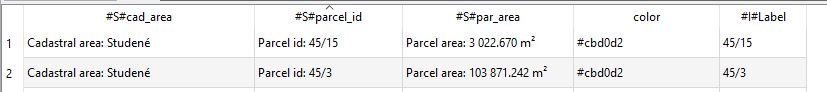
Points, lines, and polygons should contain the “color” attribute, the color they will be displayed. All other attributes that you want to display in the popup window must contain a “#S#” string in the attribute name. To display a label, just add the “#I#Label” attribute for points, lines, or polygons.

For more information contact us.